
Vedeţi lumea din adâncuri.

SONAR CU SCANARE LA DEFINIŢIE ULTRA-ÎNALTĂ
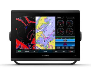
Obţineţi sonare de scanare integrate la ultra-înaltă definiţie SideVü şi ClearVü cu palete de culori vii şi cu contrast ridicat pentru a vă ajuta să distingeţi peştii de structuri. GPSMAP® 743xsv acceptă şi funcţiile sonarului tradiţional CHIRP de 1 kW.

COMPATIBILITATE CU SONARUL PANOPTIX™
Asociaţi cu Panoptix sau Panoptix LiveScope™ sonar în timp real, uşor de interpretat (traductor comercializat separat) pentru a vedea totul în jurul bărcii în timp real.
Navigaţi cu uşurinţă.

MAI RAPID, MAI CLAR, MAI INTELIGENT
Cu o capacitate sporită de procesare şi un design nou subţire cu sticlă de la o margine la alta şi o amprentă a unităţii mai mică, acest plotter de 7 inchi este uşor de montat într-o varietate mai mare de configuraţii de bord.

OPTICĂ ÎMBUNĂTĂŢITĂ
Noile afişaje cu rezoluţie superioară de 7 inchi asigură lizibilitate îmbunătăţită în lumina soarelui, cu 60% mai mulţi pixeli faţă de dispozitivele GPSMAP de 7 inchi din generaţiile anterioare.

DIAGRAME OPŢIONALE BLUECHART® G3 VISION®
Aceste diagrame opţionale oferă cele mai performante date Garmin şi Navionics® , tehnologie Auto Guidance3 şi alte caracteristici de navigare premium.

PACHET RADAR OPŢIONAL
Pentru a vă ajuta să evitaţi intemperiile şi traficul pe apă, radarul cu cupolă compact de 4 kW GMR™ 18 HD+ este disponibil ca opţiune grupată cu pachetul chartplotter/sonar GPSMAP.
Sail and navigate with ease.

GARMIN SAILASSIST™ SAILING FEATURES
View laylines, race start line guidance, enhanced wind rose, heading and course-over-ground lines, true wind data fields and tide/current/time slider, wind angle, set and drift, wind speed, polars and more3.

OPTIONAL PREMIUM NAVIGATION FEATURES
These optional charts offer the best of Garmin and Navionics® data, Auto Guidance3 technology and other premium navigation features.

SAILING POLARS
Use the polar table to see key data, including how fast you should go at a certain wind angle and speed — so you know whether you need to adjust sail trim.

GARMIN MARINE NETWORK
If you have multiple compatible Garmin devices on your boat, you can share information — such as maps, user data, radar and IP camera video — among them.

NMEA 2000® AND NMEA 0183 NETWORKS
Connect to compatible autopilots, digital switching, weather, Fusion-Link™ audio system, media, VHF, AIS and more from one screen.

ACTIVECAPTAIN® APP
Built-in Wi-Fi® connectivity pairs with the free all-in-one mobile app for access to the OneChart™ feature, smart notifications, software updates, Helm, Garmin Quickdraw™ Community data and more4.

INTEGRATED ANT® TECHNOLOGY
Connect with some of your favorite devices, such as quatix® marine watches, gWind™ Wireless 2 transducers, GNX™ Wind marine instruments and wireless remote controls.

J1939 CONNECTIVITY
Now you can connect your chartplotter to different kinds of engines, including select Yamaha engines.

ONEHELM FEATURE
This feature brings together all the operations and capabilities of select third-party devices, such as EmpirBus™ digital switching, on one screen.
In The Box
- GPSMAP 723xsv chartplotter
- microSD™ card preinstalled
- Power cable
- NMEA 2000® T-connector
- NMEA 2000 drop cable (2 meters)
- 8-pin transducer to 12-pin sounder adapter cable
- Bail mount kit with knobs
- Flush mount kit with gasket
- Protective cover
- Trim piece snap covers
- Documentation
With 18 HD+ Radar
Above contents plus:
- GMR 18 HD+ radome
- Mounting hardware kit
- Power cable (15 m)
- Network cable (15 m)
- Installation instructions
- Mounting template
Specification
General
| DIMENSION | 7.6″ x 5.5″ x 2.9″ (19.2 x 14.0 x 7.4 cm) |
| TOUCHSCREEN | Yes |
| INPUT | Touchscreen |
| DISPLAY SIZE | 6.1″ x 3.5″; 7.0″ diagonal (15.4 x 9.1 cm; 17.8 cm diagonal) |
| DISPLAY RESOLUTION | 1024 x 600 pixels |
| DISPLAY TYPE | WSVGA |
| WEIGHT | 2.8 lbs (1.3 kg) |
| WATERPROOF | IPX7 |
| MOUNTING OPTIONS | Bail, flush or flat (Garmin does not offer any hardware or accessories for a flat-mount installation. Professional tools and knowledge is required.) |
Maps & Memory
| ACCEPTS DATA CARDS | 2 microSD cards (back of unit) |
| WAYPOINTS | 5000 |
| TRACK POINTS | 50,000 |
| TRACKS | 50 saved tracks |
| NAVIGATION ROUTES | 100 |
Sensors
| HAS BUILT-IN RECEIVER | Yes |
| RECEIVER | 10 Hz |
| NMEA 2000 COMPATIBLE | Yes |
| NMEA 0183 COMPATIBLE | Yes |
| GPS | Yes |
| GLONASS | Yes |
| GALILEO | Yes |
| SUPPORTS WAAS | Yes |
Built-in Maps
| BUILT-IN AUTO GUIDANCE | Yes |
| BLUECHART (COASTAL) | Yes |
| LAKEVU (INLAND) | Yes |
| (SOUNDER) TIDE TABLES | Yes |
Optional Map Support
| LAKEVÜ G3 | Yes |
| LAKEVÜ G3 ULTRA | Yes |
| GARMIN NAVIONICS+™ | Yes |
| GARMIN NAVIONICS VISION+™ | Yes |
| (SOUNDER) TOPO | Yes |
| STANDARD MAPPING | Yes |
| GARMIN QUICKDRAW CONTOURS | Yes |
| RASTER CHART SUPPORT | Yes |
Chartplotter Features
| SMART MODE COMPATIBLE | Yes |
| AIS | Yes |
| DSC | Yes |
| SUPPORTS FUSION-LINK™ COMPATIBLE RADIOS | Yes |
| GSD BLACK BOX SONAR SUPPORT | Yes |
| GCV BLACK BOX SONAR SUPPORT | Yes |
| ACTIVECAPTAIN® COMPATIBLE | Yes |
| GRID (GARMIN REMOTE INPUT DEVICE) COMPATIBLE | Yes |
| WIRELESS REMOTE COMPATIBLE | Yes |
| SAILING FEATURES | Yes |
| SPOKEN AUDIO ALERTS | Yes |
| ONEHELM SUPPORT | Yes |
Connections
| NMEA 2000 PORTS | 1 |
| CONNECTIONS NMEA0183 INPUT PORTS | 1 |
| NMEA 0183 INPUT (TX) PORTS | 1 |
| VIDEO INPUT PORTS | 1 (BNC composite) |
| J1939 PORTS | 1 |
| GARMIN MARINE NETWORK PORTS | 1 |
| 12-PIN TRANSDUCER PORTS | 1 |
| USB PORTS | Yes |
| BNC EXTERNAL GPS ANTENNA PORT | Yes |
| BLUETOOTH® CALLING | Yes |
| ANT+ (CONNECTIVITY) | Yes |
| GARMIN WI-FI NETWORK (LOCAL CONNECTION) | Yes |
Sonar Features & Specifications
| DISPLAYS SONAR | Yes |
| POWER OUTPUT | 1 kW |
| TRADITIONAL SONAR (DUAL FREQUENCY/BEAM) | built-in (single channel CHIRP, 70/83/200 kHz, L, M, H CHIRP) |
| CLEARVÜ | built-in 260/455/800/1000/1200 kHz |
| (SOUNDER) SIDEVÜ | built-in 260/455/800/1000/1200 kHz |
| PANOPTIX™ SONAR | Yes |
| LIVESCOPE | Yes |
Electrical Features
| POWER INPUT | 10 to 32 Vdc |
| TYPICAL CURRENT DRAW AT 12 VDC | 1.18 A |
| MAXIMUM CURRENT DRAW AT 12 VDC | 2.96 A |
| MAXIMUM POWER USAGE AT 10 VDC | 35.9W |


Reviews
There are no reviews yet.