


/*! elementor – v3.12.1 – 02-04-2023 */
.elementor-heading-title{padding:0;margin:0;line-height:1}.elementor-widget-heading .elementor-heading-title[class*=elementor-size-]>a{color:inherit;font-size:inherit;line-height:inherit}.elementor-widget-heading .elementor-heading-title.elementor-size-small{font-size:15px}.elementor-widget-heading .elementor-heading-title.elementor-size-medium{font-size:19px}.elementor-widget-heading .elementor-heading-title.elementor-size-large{font-size:29px}.elementor-widget-heading .elementor-heading-title.elementor-size-xl{font-size:39px}.elementor-widget-heading .elementor-heading-title.elementor-size-xxl{font-size:59px}
FEATURES
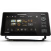
- Full-HD Display with Cross Touch® Interface: The XPLORE series brings stunning detail with a 1280H x 720V Full-HD display. Enjoy crystal-clear views of sonar and chart images, ensuring you never miss a thing. Control it your way—using the responsive touchscreen or the keypad.
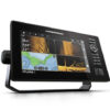
- MEGA Side Imaging+: Experience unparalleled clarity with Side Imaging that reaches up to 200 feet on both sides of your boat. Gain an edge with 20% more detail and 60% greater range than standard MEGA Side Imaging sonar, helping you uncover more fish and underwater structures.
- MEGA Down Imaging+: Achieve unmatched underwater clarity with Down Imaging coverage up to 200 feet below your boat. See more fish and structures with 20% enhanced detail and 60% deeper range compared to traditional MEGA Down Imaging sonar.
- Dual Spectrum CHIRP Sonar: Know what’s beneath before you cast with precise fish arches and a clear view of fish-holding structures. Powered by the Low-Q CHIRP transducer, this sonar lets you choose between Wide Mode for maximum coverage or Narrow Mode for detailed precision.
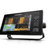
- Internal GPS and Humminbird Basemap: Navigate confidently with an enhanced basemap that displays underwater terrain and key points of interest. Identify buoys, hazards, marinas, contours, and more. Includes charts for over 10,000 lakes and coastal coverage for the continental U.S.
- Premium Chart Compatibility: Access a comprehensive range of premium chart options. Enhance your fishing experience with optional LakeMaster® and CoastMaster™ charts from Humminbird, or choose compatible Navionics® charts for a complete underwater view.
SPECS
| Model | XPLORE 9 CMSI+ Fish Finder |
| Product Code | 412000-1 |
| Series | XPLORE |
| UPC | 0082324058653 |
| Display Size – Diagonal | 9 in |
| Display Pixel Matrix | 1280 x 720 |
| Transducer Included | XM 14 HW CMSI T |
| Compatible With | Minn Kota US2 Sonar, Minn Kota Built-In MEGA DI, Minn Kota Talon/Raptor, Minn Kota i-Pilot Link, Minn Kota Built-In MEGA SI, MEGA Live, NMEA 2000, MEGA 360, Radar, AutoPilot, One-Boat Network |
| Features | Touch Screen, Networking, Down Imaging, Built In GPS, Bluetooth, Side Imaging, Built In Mapping, MEGA Imaging+, Wi-Fi, MEGA Imaging |
| Memory Card Slot | Dual Micro SD |
| Sonar-Standard | Dual Spectrum CHIRP, MEGA Side Imaging+, MEGA Down Imaging+ |
| Sonar-Optional | 50/83/200 kHz, Airmar High, High Wide, Medium, Medium Wide, and Low |
| CHIRP – Frequencies Supported | Narrow Mode (180-240 kHz), Wide Mode (140-200 kHz), Full Mode (150-220 kHz) |
| Sonar-Frequencies Supported | 50/83/200/455/800 kHz, HW DSC CHIRP, and MEGA |
| Depth-Sonar | 3,500 ft (optional 50 kHz), 1,200 ft (standard transducer) |
| CHIRP – Imaging Frequencies Supported | 455 kHz SI+ (405-505 kHz), 455 kHz (420-520 kHz), MEGA SI+ (1050-1175 kHz) |
| Depth-Down Imaging | 200 ft (MEGA), 400 ft (455 kHz) |
| Range-Side Imaging (Side-To-Side) | 800 ft (455 kHz), 400 ft (MEGA) |
| Interface | Touch Screen, Keypad Control |
| Power Input | 10.8-20 VDC |
| Power Output Peak-to-Peak | 8000 Watts |
| Power Output RMS | 1000 Watts |
| Screen Snap Shot | Included |
| Sonar Recording | Included |
| Mount-Standard | Gimbal |
| Mount-Standard Size | 11.690 in W x 6.569 in H x 3.884 in D |
| Mount-Optional | In-Dash Mounting Kit |
| Mount-Optional Size | 6.259 in W x 11.69 in H x 3.3 in D |
| Transducer Mount Location | Transom |
| GPS Chartplotting | Included |
| GPS Receiver | Internal |
| GPS Trackplotting | Not Supported |
| Waypoints, Routes, Tracks/Points | 10,000, 50, 50/20,000 |
| 360 Imaging Compatibility | Yes |
| MEGA Live Compatibility | Yes |
| Humminbird Basemap | Included |
| LakeMaster Compatibility | Yes |
| CoastMaster Compatibility | Yes |
| Navionics Gold/HotMaps Compatibility | Yes |
| Navionics Platinum+ Compatibility | Yes |
| Platinum Compatibility | Yes |
| Minn Kota Advanced GPS Navigation Compatibility | Yes |
| Minn Kota i-Pilot Link Compatibility | Yes |
| Minn Kota Talon Shallow Water Anchor Compatibility | Yes |
| Radar Compatibility | Yes |
| 5-Port Ethernet Switch Compatibility | Yes |
| AIS Compatibility | Not Supported |
| Autopilot Compatibility | No |
| Heading Sensor GPS Compatibility | No |
| Heading Sensor GPS (NMEA 2000) Compatibility | Yes |
| NMEA2000 | Included |
| Target Separation | 2.5 in |
| Upgradable Software | Yes |
| View Preset Keys | Yes |
| X-Press Menu System | Yes |
| Custom Digital Readout | Yes |
| Custom View Selections | Yes |
| Display Colors Grayscale | 24-Bit |
| Display Type | Color TFT |
| Speed | Included |
| Temperature | Built In |
| Temperature Alarm | Yes |
| Temperature Graph | Yes |
| HDMI Compatible | No |
| Warranty | Two-Year Warranty |


Reviews
There are no reviews yet.