SPECIFICATIONS
| BRAND | Garmin |
|---|---|
| PRODUCT | Garmin Navionics+ marine charts |
| PART NUMBER | 010-C1258-00 |
| REGION | Black Sea & Azov Sea |
| MAP TYPE | Coastal and inland marine cartography |
| COMPATIBILITY | Garmin chartplotters |
| SUBSCRIPTION INCLUDED | One-year subscription |
| DAILY CHART UPDATES | Via the ActiveCaptain smart-device app |
| AUTO GUIDANCE+ | Suggested dock-to-dock routings through channels, inlets, marina entrances and more |
| DEPTH RANGE SHADING | Up to 10 color-shaded target depth ranges |
| CONTOURS | Up to 1′ contours |
| SHALLOW WATER SHADING | User-defined depth shading for shallow waters |
| ACTIVECAPTAIN COMMUNITY | Community-sourced points of interest, including marinas, anchorages, hazards, businesses and more |
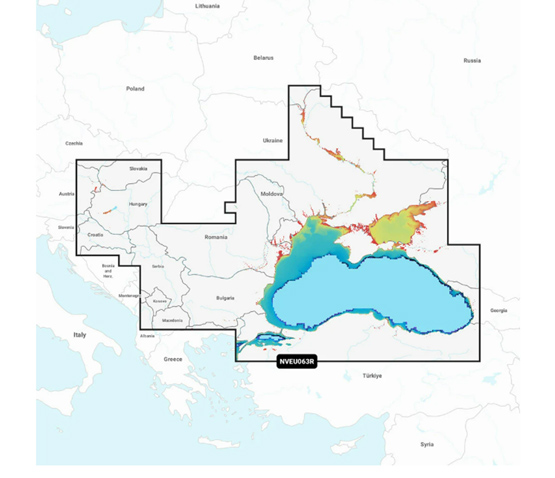
COVERAGE
Detailed coverage of the Dardanelles, the Sea of Marmara, the Bosporus Strait, the Black Sea, the Dnieper River to the Belarus/Ukrainian border, the Bug River to Nikolayev, the Kuban River to Krasnodar, the Danube River from Vienna to its delta, the Sava River, the Danube – Black Sea Canal, Lake Balaton, Lake Ferto, the Tisa River to Lake Tisza and the Sea of Azov.
| SEAS AND STRAITS | Dardanelles, Sea of Marmara, Bosporus Strait, Black Sea, Sea of Azov |
|---|---|
| RIVERS AND CANALS | Dnieper River to the Belarus/Ukrainian border, Bug River to Nikolayev, Kuban River to Krasnodar, Danube River from Vienna to its delta, Sava River, Danube – Black Sea Canal, Tisa River to Lake Tisza |
| LAKES | Lake Balaton, Lake Ferto, Lake Tisza |
| DETAILED PORT AND CITY COVERAGE | Varna, Constanta, Odessa, Nikolayev, Sevastopol, Mariupol, Taganrog, Temryuk, Novorossiysk, Batumi, Hopa, Samsun, Eregli, Istanbul and Canakkale |
NOTES
| AUTO GUIDANCE+ NOTE | Auto Guidance+ is for planning purposes only and does not replace safe navigation operations. |
|---|---|
| SUBSCRIPTION NOTE | Renewing the subscription keeps access to daily updates and new content downloads. |
Reviews
There are no reviews yet.